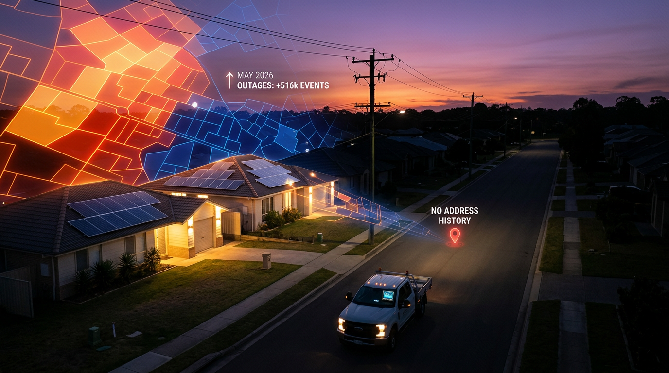
There is no public source in the United States where you can type in a street address and see its power outage history. Utilities logged 516,481 outage events in May 2026 alone, and every one of them happened at specific addresses. The public record just stops at the county, and the live maps erase each event the moment the power comes back.
That gap surprises everyone who hits it: the homebuyer checking a property, the remote worker who lost three workdays last quarter, the installer trying to read a prospect's block. Each of them ends up on the same dead-end pages. Here's what every source actually shows, and where the real answer lives.
Can you look up power outage history by address?
No. No national database, free or paid, returns outage history for an arbitrary U.S. address.
What exists instead is a patchwork. Your own utility holds the history for your own service address and will usually confirm it if you ask. PG&E customers can check a specific address through the utility's own tools. For every other address in the country, the public data stops at the county line.
Most of what ranks for this search reflects that patchwork: how-to articles that walk you to your utility's live outage map, which shows the current minute and nothing else, or a lookup tool that covers exactly one utility. Neither answers the question for a general address, so it's worth going source by source.
What can your utility tell you about past outages at your address?
Quite a lot, as long as the address is your own. Every utility's outage-management system logs which circuits failed and when, and customer service can pull what that meant for your meter. Call and ask for an outage verification letter — a written confirmation of the dates and durations of past outages at your service address. Utilities produce these routinely because insurance and food-spoilage claims require them.
The limits are real, though. The history covers your address only, with your current utility only, and many reps can see just the last several months. You can't call about an address you don't have an account at, which closes this route for homebuyers and installers alike.
PG&E is the exception most people find. Its tools let customers check outages affecting a specific address, which is why an entire niche site exists doing nothing but repackaging PG&E outage data. That a single-utility wrapper can sustain a website tells you two things: the demand for address-level history is real, and almost no other utility meets it.
Does the government publish outage history by address?
No. The federal data is genuinely good on history and genuinely blind below the county.
The Department of Energy runs two feeds. EAGLE-I, maintained by Oak Ridge National Laboratory, archives outage events going back years. ODIN collects utility-reported events in near real time, with start times, customer counts, and causes when the utility supplies one. Both report at the county level. A typical urban county contains 50 to 200 ZIP codes, so a county row averages hundreds of thousands of addresses into one line. We walked through where to actually find outages by ZIP separately, and an address is a far tighter ask than a ZIP.
State utility commissions are the other government source. They require annual reliability filings — SAIDI and SAIFI, the industry's average-minutes-out and average-interruptions-per-customer metrics. Those numbers describe an entire utility's year in two averages. They tell you the grid's GPA, not whether one block keeps failing.
News archives and the National Weather Service storm database can confirm that a big event happened in an area on a date. Neither says anything about a specific address.
Why doesn't a public address-level outage database exist?
Because utilities track outages by equipment, not by address, and nobody requires them to translate.
When a feeder trips, the utility's outage-management system records which circuit failed, when, and how many meters sat downstream. With smart meters, most utilities know exactly which addresses lost power. The data exists internally. It just never leaves: there's no regulatory mandate to publish it, and utilities treat per-address records as customer data when anyone asks.
The public-facing version is the live outage map, which is built for the customer sitting in the dark right now. It draws a polygon, posts an estimated restoration time, and deletes everything once power returns. We covered why those maps have no memory in a separate post.
Public-records requests are the last resort, and they mostly fail. They run per-utility, take weeks, and are routinely declined on customer-privacy grounds. For context on how little utilities volunteer even at the event level, 83% of U.S. outage events carry no published cause at all. Utilities that won't say why the power went out were never going to publish per-address histories.
Who actually needs outage history for a specific address?
Four groups keep landing on this search, and they split cleanly by how many addresses they care about.
- Homebuyers vetting a property before an offer — frequent outages change the calculus on a home office, a sump pump, a freezer full of food.
- Claim filers who need to prove an outage happened; the verification letter from the utility handles this.
- Remote workers and landlords deciding whether a specific property's grid is dependable.
- Solar, generator, and battery installers reading outage history across prospects' addresses to decide where to canvass and what to lead with at the door.
The first three care about one address each, and the utility route (call, ask, get the letter) mostly works for them. Installers care about thousands of addresses they don't have accounts at, so that route doesn't exist for them at all.
How do installers get address-level outage history?
By reconstruction. The history that no source publishes can be rebuilt from the events utilities do report.
GridProfile collects outage events from DOE ODIN plus the public feeds of 160+ utilities and cooperatives, then intersects every event with a known footprint against an index of 164 million U.S. addresses across 38 states. The output names the streets that lost power, with house-number ranges, durations, causes when published, and repeat-event flags. In a validation test in Kirkland, Washington, an outage the utility reported as 18 customers resolved to exactly 18 addresses on NE 68th Pl.
That's the practical substitute for the address-level database that doesn't exist. At the territory level, the same pipeline answers which ZIPs inside a county actually lose power. At the door, it produces street lists with repeat-victim flags that tell a rep which blocks sat in the dark twice last month. The 50-state reliability table is the widest cut of the same data.
If the address you're researching is your own, call your utility and ask for the letter. If the addresses you're researching are a territory, grab a free grid profile — pick a state and up to three counties, and we'll email you the ZIP-level outage history with the specific streets that lost power most recently.